
The men who put Barberton on the map
When gold was discovered in the De Kaap Valley, Barberton did not simply appear on a ready-made map.



Today, finding Barberton on a map takes little more than a few taps on a cellphone. The roads, rivers, mountains and towns are all neatly recorded, and even some of the old mining areas can still be identified. In the 1880s, it was a very different story.
When gold was discovered in the De Kaap Valley, Barberton did not simply appear on a ready-made map. The goldfields were part of a rugged and relatively little-mapped landscape, and as thousands of people rushed towards the new diggings, surveyors had the formidable task of recording the mountains, rivers, roads, farms, settlements and mining claims that were transforming the area.
Among the men who helped turn this rapidly changing territory into something that could be accurately represented on paper were the Jeppe family.
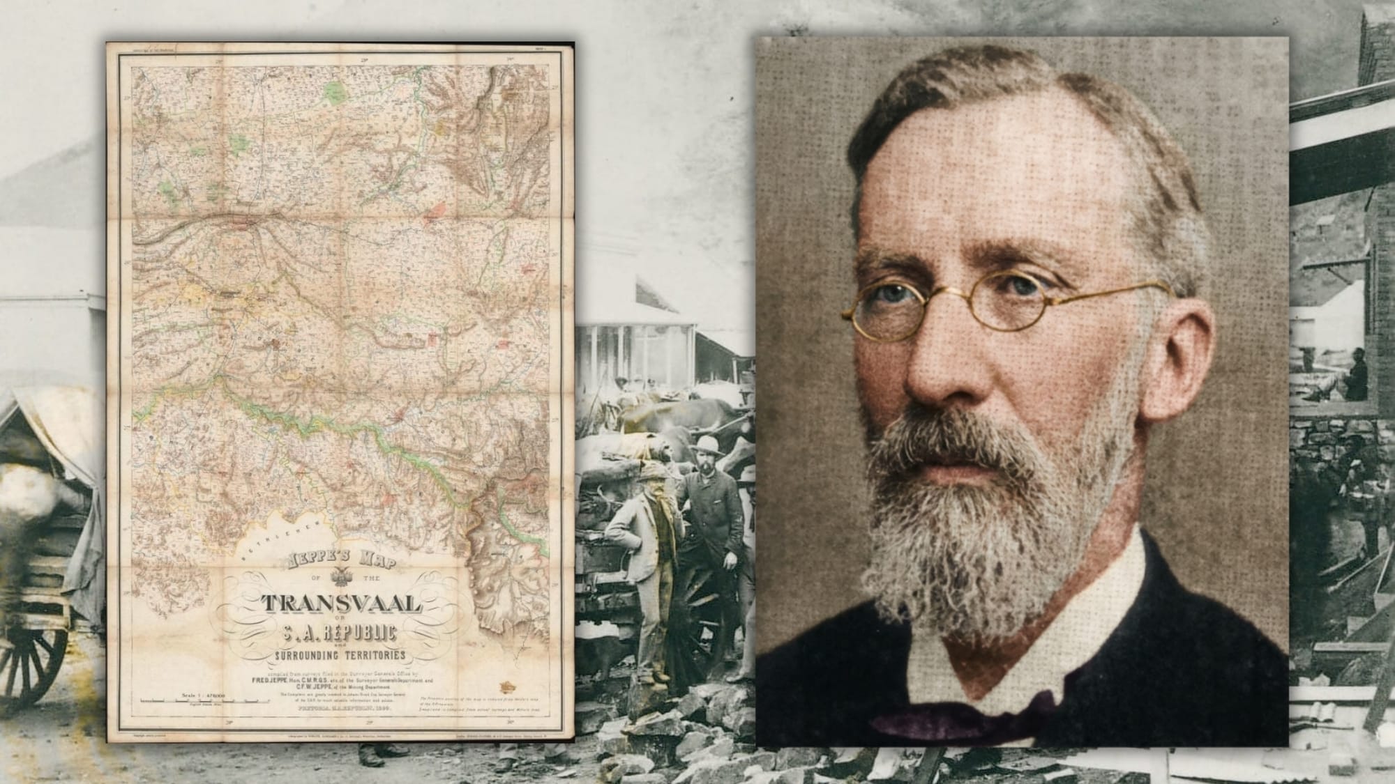
Friedrich Heinrich Jeppe, better known as Fred Jeppe, was born in Rostock, Germany, in 1834. He came to South Africa in the early 1860s and initially worked as a merchant before becoming involved in the postal service. His career eventually took him into government service, where his interest and ability in cartography developed into a lifelong contribution to the mapping of the South African Republic.
Jeppe became a surveyor and cartographer and eventually worked in the Surveyor-General's Department. His maps were produced during a period when the Transvaal was changing at an extraordinary rate. New settlements were being established, roads were being opened, railways were eventually being built and, most importantly, gold was changing the economic and geographical importance of entire regions. Barberton was at the heart of this transformation.
The discovery of payable gold in the De Kaap Valley in 1884 brought prospectors and fortune seekers pouring into the region. Barberton was proclaimed a township on July 24, 1884, and the settlement grew with remarkable speed.
However, a goldfield was not simply a collection of holes in the ground. Mining claims had to be surveyed and recorded. Roads had to be identified. Rivers and mountain ranges had to be named and located. Farms and properties needed boundaries, while the rapidly developing settlements needed to be represented accurately. Maps became an essential part of the gold rush.
They were useful to miners and prospectors, but they were equally important to government officials, transport riders, engineers, investors and businessmen. A map could show where the goldfields were, how they were connected and where roads and settlements were developing. One of the surviving maps from this period gives us a remarkable glimpse of Barberton during its gold-rush years.
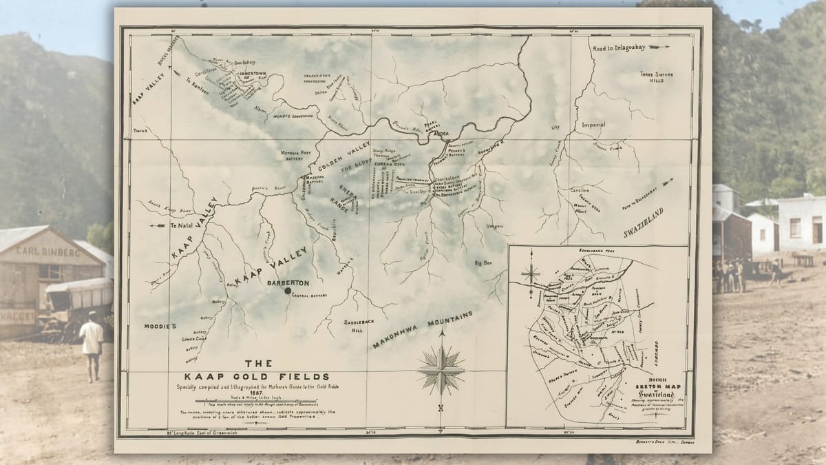
An 1887 map of the Kaap Goldfields, compiled by government surveyors S.T. Erskine and R. Pizzighelli, records a landscape that will be familiar to anyone interested in Barberton's history. Barberton appears alongside places such as Jamestown, Eureka City and Avoca, while the map identifies mining areas including Sheba Hill, Rimer's Creek, Imperial Reef and Lily Reef. Rivers, roads, paths, hills and other geographical features are also shown.
For modern residents, such a map is much more than an old piece of paper. It is a snapshot of Barberton at the height of its first gold rush. Some of the names have survived. Others disappeared as the mining settlements faded away. Roads changed, properties changed hands and the landscape was gradually transformed, but the old maps preserve a record of the places that once made up the bustling goldfields. Fred Jeppe's work belongs to this wider tradition of documenting the rapidly changing Transvaal.
His son, C.F.W. Jeppe, became involved in mapping and mining administration and eventually worked in the Mining Department. Father and son would ultimately collaborate on one of the most important maps of the old South African Republic.
Known as Jeppe's Map of the Transvaal or South African Republic and Surrounding Territories, the map was published in 1899. It was an extraordinary undertaking. The map was produced in six sheets and incorporated information from surveys held in the Surveyor-General's Office. It showed towns, rivers, roads, railways, farms, goldfields, mountains, postal routes and telegraph lines across a vast area. For a country undergoing rapid development, it was an invaluable record.
Barberton and the surrounding goldfields formed part of this much larger geographical picture. The map placed the De Kaap Valley and its mining settlements within the wider network of the Transvaal, showing how isolated goldfields were connected to the rest of the country.
There was also a poignant personal story behind the map. Fred Jeppe became seriously ill while the work was being undertaken and died in July 1898. His son continued the work, and the great map was published in 1899, after his father's death. The finished map therefore represented not only years of surveying and cartographic work, but also the culmination of a father and son's shared project.
It appeared at a particularly significant moment in South African history. Within months, the Anglo-Boer War would break out. The map that had been produced to document the geography and development of the South African Republic acquired another importance. British forces used existing maps and geographical information when planning military operations, and the detailed Jeppe map became part of the cartographic resources available during the conflict.
It is an extraordinary thought that a map created partly to document a developing country could soon become a tool in a war that would fundamentally change that country's future. For Barberton, however, the significance of these old maps lies closer to home. They allow us to see the goldfields as they were during the brief and frenetic period when the town was growing from a remote settlement into one of the most exciting gold-rush centres in southern Africa. The names on the maps tell their own stories.
Sheba Hill reminds us of the famous Sheba Mine, whose gold deposits would continue to play an important role in Barberton's history. Jamestown and Eureka City evoke the settlements that sprang up around the gold workings. The creeks, hills and roads recorded by the surveyors show how closely the early mining community depended on the natural landscape. Even the roads were important.
Before the railway reached Barberton, people and supplies had to make their way into the goldfields by wagon. Mountain passes, rivers and difficult tracks could turn a journey into an ordeal. The maps therefore became practical tools for a community whose survival depended on knowing how the various parts of the goldfields were connected.
There is something wonderfully appropriate about the fact that the story of Barberton's gold rush can still be traced through these old maps. Gold itself is notoriously difficult to follow through history. It was dug from the earth, melted down, sold and carried away. Claims changed hands, mines opened and closed, and fortunes were made and lost.
A century and more later, they allow us to look over the shoulders of the surveyors and see what they saw. They preserve old names, forgotten settlements and roads that have disappeared from the modern landscape. They also remind us how much effort went into creating the Barberton that we know today.
Fred Jeppe and his son were mapping a country that was changing almost faster than it could be measured. Their work captured the Transvaal on the threshold of a new century, when gold, railways, expanding towns and political tensions were reshaping the landscape.
Today, when we look at Barberton on a modern digital map, it is easy to forget that every road, river and place name has a history. Long before satellites and smartphones, surveyors walked, rode and travelled across this country with instruments, notebooks and painstaking measurements.
They turned mountains into contours, distances into lines and scattered settlements into identifiable places. They helped turn the chaotic geography of the gold rush into a landscape that could be understood. Somewhere on those old sheets of paper, among the creeks, claims, reefs and rough tracks of the De Kaap Valley, was a young gold-rush town that would become the Barberton we know today.
The men who came looking for gold may have put Barberton on the map in one sense, but the men who surveyed it made sure it stayed there.
 Mariana Balt
 Naomi Roebert
 Liz Thorne
Comments ()